Monday, June 30, 2014

Day 40--Part 2--On the Left, and Back to Miles


Woo Hoo! I've made it to Scotland! 

The flight was uneventful. In fact, there were only 10 people on the plane. Makes for quick boarding (even though one of the crew, a flight attendant, was late), and quick exit upon arrival. Scotland is also one hour behind, so I gained an extra hour today. It was a good day to have an extra hour.

I breezed through passport control and customs. I was the only person on the flight that was not a citizen of the EU. My bags were waiting for me right after the passport control. I wheeled everything out to the main part of the airport. First I changed money. Similar to Scandinavia, not all pounds are the same. Most places outside of Scotland don't like to take the Scottish Pounds. But all (except Northern Ireland) will take the Bank of England Pounds. So, the guy gave me all BoE Pounds (and some for N. Ireland). It's nice to be back to something sort of similar to dollars.

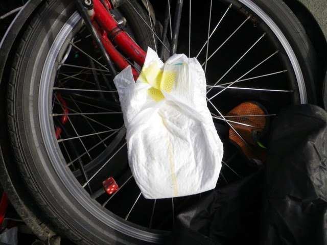
I asked an airport employee if there was someplace special I should unpack Betsy. He said anywhere was fine. So, I set to work. The diaper padding worked great. Betsy was in perfect shape. It took me about 45 minutes to get everything put together and ready to go. I exited the airport...and had no idea which way to turn. I turned on the Garmin and found out which way to go. There was a fabulous Bikeway into Aberdeen. I also have to get used to riding on the left. It brought back memories of New Zealand. I put my mirror on the right side, so that is helpful to remind me. 

Closer into Aberdeen, it became more difficult to figure out which way to go. I was sort of just willy nilly just going along...okay, that's really busy over there, I'll just go this way. Then I spotted a Cycle Route 1 sign. I thought, well, I don't know if I want Route 1, but I may as well follow it until I decide what I do want. It took me on a serpentine route to the city center. Here's a few things I passed.
A nice neighborhood.
In Seaton Park
The Cathedral Church of Machar
High Street

On High Street (although the photo doesn't show it), there were a lot of people waiting. I'm not sure what they were waiting for. The cobblestones were very annoying to ride on. I was glad when I got through them.

I continued following the signs until I came to some festival that was getting set up. The roads were closed to cars, but I could bike through. Except at one point it was completely blocked off. I could hear music. I'm wondering if it was some sort of concert getting ready. There weren't so many people yet, but I could tell they were getting ready. Since I really had no idea where I was going, I thought perhaps I should figure out a direction. I turned on the Garmin and put in Stonehaven. That was the first town I was heading to tomorrow. I figured I would get going in the right direction, then see about camping. 

I also needed food. I spotted a Co-op grocery store and made a stop. Since I don't have any fuel yet, I didn't get much that has to be cooked (just hot cocoa). I got some kind of Scottish bread things called Butteries. Looked good to me!

As I was working my way out of the city, I came across a Subway. Since I had no fuel, it seemed like a perfect time to check a Scotland Subway off the list. 

After eating, I checked the Garmin for camping. There was Queen Elizabeth Caravan Park about 10 miles away. It was also in the direction to Stonehaven. Perfect! It was a little before 7:00 when I left Subway.

I followed the Garmin directions. It was a good road with a bike lane, and then when there was no bike lane the road was pretty quiet.
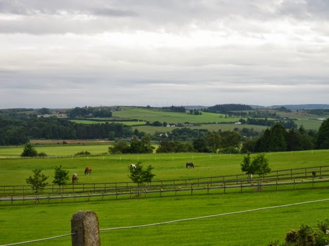
Isn't this exactly how you picture Scotland?
As I crested a small hill, this came into view. Pretty awesome! 

I came down the hill and, voila, I was in Stonehaven! Turns out the Caravan Park is in Stonehaven. That's excellent! I pulled up to the office at 7:53. They close a 8:00. Just made it! The couple are very nice. The man escorted me to the tent site. Although the showers and all are free, there is no cooking facility. I can get warm water for "warm" cocoa in the morning, but that's about it. I'll try to find fuel tomorrow. The gentleman said he would have a look in the phone book, and tell me in the morning where I might find fuel. There are a couple of French boys cycling who are from Lille. They have fuel, but they brought it from France.

I took a walk on the beach after everything else was done. It's really quite beautiful, and even though I think it's still the North Sea, it seems very different here.
Rocky beach

I'm a bit ahead, since I made it to Stonehaven. Tomorrow I'm going to go see the Dunnottar Castle. It's the main attraction here.

Scotland Miles today: 25.5 (and, yes, it is miles--not kilometers)

Here's two signs I saw today that were interesting.
So polite about it.
I think this is hilarious!


Day 40--Part 1--Leaving Norway, Or...

...Lesson Learned, Never Let Someone Else Book Your Ticket

I slept in this morning until a whopping 6:55. It was too bright in my tent to sleep any longer. I had done  what I could do to prepare for my flight last night (considering I still had to ride to the airport). I finished off my food (I'll restock in Aberdeen). Last night, I gave a young German couple the fuel canister. They were traveling in a VW Camper van with their 10 month old daughter, Amelie. They were very nice and spoke very good English.

The ride to the airport was very easy. Once I got to the main road, their was a Bikeway the entire way to the airport.
There's the airport.
The bike path looks relatively new. 

It was 3.5 miles from Olberg to the airport. I arrived at 8:50. My flight is not until 2:15, so I had plenty of time to carefully diaper up Betsy. I stopped outside where there were some luggage carts (free--yay!), and began the packing process. First was Betsy. I removed the pedals and put them in the repair kit bag. I dumped out the small amount of water that had accumulated in the seat tube (this is something I think Bike Friday should find a way to eliminate). I folded, and bungy corded Betsy together. I must have left the plug that goes into the steering mast hole in the suitcase, because I couldn't find it. I just stuffed a diaper in the hole (hopefully, it won't get bent). I wrapped the sharp things and those parts that needed protection with the diapers. If Betsy survives the flight with the diaper protection, I would highly recommend diapers as a great packing material. They are sturdy and come with their own "tape" (Velcro tabs)! I only used a small amount of tape on the diapers I used for the big chainring. The rest I was able to use the Velcro on the diapers.

No tape required!

A small pack of 23 Newborn size diapers was plenty. I think it could even pack up two bikes. Of course, there is a downside. When I get to Aberdeen, I will just throw them away. If I was packing Betsy in the bag to fly home from Frankfurt (instead of the suitcase), I think I would try to carry them with me. I'm sure they would be reusable. However, if I was using bubble wrap, I would do the same thing, throw it away. Could I have used my towel and clothes? I suppose I could, but Betsy is very dirty. Better to soil a diaper than my clothes--HA HA!

After getting Betsy taken care of, I turned to packing everything else into the Chinese Shopping Bag. That was no problem (even with all the snow globes and other souvenirs I've collected, it still only weighed 19kg--well under the 23 allowed). I even remembered to take my pocket knife out of my handlebar bag and put it in the repair kit! 

I loaded everything onto a luggage cart and wheeled into the airport. I went to a kiosk to print my boarding pass. I put in the confirmation number. My reservation couldn't be found. I tried a couple of other things with no luck. I went to the SAS info desk and told the lady. She tried looking it up. She found the reservation, but said no ticket was issued. This was a mystery as I had paid for the ticket (supposedly). Christian had made the reservation through some German travel website. Since it was all in German, I have no idea what happened, why no ticket was issued. Anyway, I ended up booking another ticket (I'll double check when I get home to make sure I wasn't charged for the other ticket). Of course, it was more expensive, but I didn't really have a choice. Lesson learned is not to let someone else book your ticket through an unknown website in a language you can't read.

Ticket in hand, I went to bag drop. I knew I had to pay for the second bag. I took care of that, and sent Betsy and the CSB on their way. I had 200Kr left, so I got some lunch. 

Now, I will head through Security and go wait at the gate. Sadly, although it appears the airport has wifi, it won't upload my posts, and I can't check my email. I had sent an email to a Warmshowers host in Aberdeen, but I don't know if they've responded. I will probably end up at a campground. Here's a parting shot appropriate for the day so far.

Day 39--Half Way and Last Day...

Of riding in Norway.

Yep, today was my last day of riding in Norway. Tomorrow, I have just a few miles to get to the airport. Also, today was the halfway day. It's the 39th day of riding, but the 40th day since arriving in Germany. I have 80 days total.

The day's ride was fairly easy, and uneventful. I said goodbye to Cornelius this morning, and we both wished each other a good trip. He was planning to go to the other side of Stavanger. 

As Cornelius had told me, today's ride was much less difficult than yesterday. However, I also didn't stay completely on the North Sea Route. First of all, I didn't go back to where I'd left the route yesterday to get to the campsite. 44 continued around and back out to the Coast anyway. When I came to the first route sign, I saw that it was an uphill climb on a gravel road. No thanks, I'll pass...right on by. I've become much more savy about the ways of my friends, the brown signs. They like to snake around and provide a variety of surfaces to ride on. I was not in the mood for uphill gravel. I continued on 44. There was virtually no traffic, since this is Sunday, and it was early.
Only the sheep, and occasional fishing boat were out.

Once I climbed over the ridge to the Coast, the route remained mostly flat. Of course, that meant there was also the wind. It's funny, when I was going in a more southerly direction, I had a headwind. Yet, when I have now come around the southern part of Norway, and have been heading in a more northerly direction, I still have a headwind! It's just not fair! Oh well, it wasn't terrible...
Still rocky here.
But, lots of flat fields. I saw fields of carrots. I don't think I've ever seen fields of carrots before. I was tempted to go pull one from the ground and have me a fresh Norwegian grown carrot...but I didn't.

At mid-morning snack time, I stopped in a town at a Joker store and got a muffin and some apple juice. The muffin was more like a cupcake with caramel on the inside and chocolate icing on the top. It was quite good. While I was in the shop, I looked for packing material. I have to pack Betsy in her black bag tomorrow. This being Sunday, none of the big stores are open--should have thought of that sooner. But, an idea started to form in my head...

I continued on 44. Periodically, it was the North Sea Route, then it would snake off again. I stayed on the road. I knew I was getting close when I saw this sign.

The airport for Stavanger is in Sola--kind of like Seatac is for Seattle. I came into the town of Kleppe. I saw a Co-op store. I stopped to check for packing material. I had wanted bubble wrap, but the chances of finding that in a small store was slim. So, an idea had solidified. What is cushy and is available in every shop? Give up? Disposable diapers! Betsy will be horribly embarrassed, but her sharp and fragile parts are going to be wrapped in baby diapers! We'll see how it works out...

In the town I saw a bike route sign to Sola. Even though the road I was on went to Sola, I thought I may as well take the bike route way. It was also the North Sea Route. There were both signs, until I came to a place where there was only the North Sea sign. I looked on the Garmin and could see that it took it's usual roundabout way, but I had time, so I followed it. It came out to the sandy beach area of the Coast. It was beautiful, and worth the "detour". 

Although, it wasn't really a detour, because it took me to the sign for the camping place I was looking for--Oldberg Camping. I arrived at 2:30 after just 43 miles. I'm sure if I had stayed on the route, it would have been many more miles. 

This place is full of people just here for the day. However, mostly they are not enjoying the beach, but are waiting in line at the Softis Stand. After I set up, and took my shower, I went to get one of these myself.
Here's the beach without many people.

Here's the most popular item at the beach.
It's thick soft-serve ice cream rolled in chocolate powder (they have other odd looking toppings too). 

This campsite cost 200Kr. The shower cost 10Kr, and there's no wifi. Not nearly as good of a deal as last night. But, there's Softis (for 38Kr)!

Tomorrow, I'm off to Scotland!


Saturday, June 28, 2014

Day 38--2/3 Mountains, 1/3 Sheep

It didn't end up being a Double Double Snicker Day, but it certainly could have (I just showed a little more restraint than yesterday, I guess).

Right out of the shoot there was a climb. It was, again, to avoid a tunnel.
See the tunnel? See the road?

It really wasn't too bad, especially compared to what came later. After the tunnel go-around, I came out to 44. I was riding along, when I spied another tunnel. This one was going downhill, and I was tempted to just ride it, but I saw the route sign said to go left. At first I thought, go left...where? Then I saw the little gravel road. Really???

It wasn't too long. Then I came back to 44. Continuing along, the route made another turn off the highway. I followed it. It dead-ended. The only thing I saw was a steep rocky trail that went down. There was no sign except one that said to watch for horses. Thinking that couldn't possibly be the route, I returned to the road and went that way. Later on, I saw where the route came out. Yep, the horse trail was the route (still no way I was going to do it)! 

I came down into Flekkefjord, and set a goal for myself to make it through the town without losing the brown signs. It wasn't so hard, as the route stayed on 44 through the town (for such a big dot on the map, there really wasn't much to the town).

After coming down into the town, the route went back up to get out. Up, up, and up some more. Once I was a bit away from the town, the traffic became almost nothing. 

As I was riding, I saw a cyclist ahead with, what looked like, red panniers. I thought, cool, another cyclist! However, when I caught up to him, it was just an old guy throwing a bag of trash into the woods along the side of the road. I gave him the I-saw-what-you-just-did look, and shook my head. Don't think he really cared.

Finally got to go down for awhile. I came into the village of Åna-Sira. The old Norwegian men were holding court in front of the Joker shop (small grocery chain). Everyone who came by stopped and chatted with the old guys. One guy really looked the part with his salty, seafaring cap, and his white beard. I had a snack of chocolate milk and a Norwegian pastry that I've had a few times (the bready one with something yellow down the middle and icing with coconut on the sides--I've seen them in almost every shop and bakery).

It was a good thing I had the chocolate milk, because the next climb was a doozy! Switchbacks, and very steep. I slogged my way to the top. At the top was this sign. I'm not sure if it means the highest part of the North Sea Route or what. I took this photo, and a bunch of people in an RV were clapping and yelling, "Bravo!". 

I rode along for awhile until I came into Jessingfjord. I came around the corner and my jaw dropped. Ahead of me the road snaked up the side of the rock mountain, going through 2 tunnels. I could see there would be no bypass road for these ones. Holy crap!

I took the two photos above after going through the first tunnel (second photo). The top tunnel was long, dark, and all uphill. I turned on my rear flasher and took off my sunglasses. Then, I pedaled like a madwoman. At one point I really couldn't see the road, I was just looking ahead to the faint light at the end. Just after the end of the tunnel, there was a parking area and viewpoint.
Way down below is the first tunnel.

So, this fjord has some WWII history. It's about a German boat called the "Altmark". Here's the info.

I sat down and ate some lunch. Then I continued with the climb. It was maybe another kilometer more.

Soon I was down to a river valley and the area of Hauge. The route did some funky snaking around through a small part, then back out to 44. Then it turned off again. This part was purely gratuitous funky road riding! However, I did see lots of sheep. The weird part is that a lot of them had tails! Maybe I'm just sheep ignorant, but I didn't think sheep had tails!
See the tails?

There were sheep in the rocky fields (I think this part of Norway is really just one big rock!), and sheep on the road too.

I got a good shot of this ram playing "King of the Rock"
Check out them curly-cue horns!

After the narrow little roads (strangely, not at all without traffic--even a motorhome went by me...I pulled over), that even turned to gravel in places, I finally returned to 44. And it was downhill! I knew I was getting close to Egersund and was happy to see the Egersund Kommune sign (like a county).

I came into town and stopped to check the Garmin for the Steinsnes Camping. Oh my God! It took me the most ridiculous way! Finally, after walking up this really steep road, I looked ahead and saw that I could have just stayed on 44! I'm less than pleased with the routing the Garmin has been doing in this part of Norway. It seems to try to completely avoid any roads that might have a car!

Anyway, I made it to the campground. This is the cheapest one yet, at 100Kr. And, the showers are free, and there is wifi (also free!). But, I look around, and I don't know what the attraction is to coming to this area of Norway. I think it's just a stop on the way to Stavanger. We are packed pretty tightly though, with lots of people here. The tent space is pretty small. There are three tents on it.
But look! There's a picnic table.

My Netherlands friend, Cornelius, made it too. He came in about 2 1/2 hours after me (when I left this morning, he was not close to being packed). He said he thought the Jessingfjord section was horrible. He had to walk through the tunnel. I looked more closely at his set-up. Not only is he pulling a BOB trailer, but he has a full compliment of panniers AND a huge bag on the rack top. No wonder he has to walk! 

Miles today: 56 very difficult ones!

I took this photo at a rest stop.
Rock, rock, and more rock!


Friday, June 27, 2014

Day 37--Double Double Snicker Day

Yes, I ate not one two-piece Snicker Bar, but two two-piece Snicker Bars! But, then again, I rode 69.7 miles of the most mountainous terrain so far (including the way to Thimmendorf).

I left Sandnes Camping around 8:00 this morning. I didn't see Stewart to say goodbye. Would have liked to. I was almost in Mandal. I got there, and went to a grocery store because I had no more lunch food, or snack food. I just got three rolls to make peanut butter and jam for lunch (Alex's homemade strawberry jam--YUM). I also got 4 Double Snicker Bars. They have two good size pieces in each bar.

When I left the store, I didn't see any route signs (of course). I just headed toward the water. I didn't see any signs until I got to Vigeland. I rode on E39 for awhile. There was a lot of traffic, but it was nothing I haven't done before. It was also more of a straight shot to Vigeland. Like I said, I finally saw the route signs there. I followed them, and I started up a steep hill. About 1/2 way up, a lady who was walking said, in Norwegian, that I was going the wrong way. That I needed to go back and take a right. I'm pretty sure she was wrong, because doing that put me back on E39. The route never goes on E39. But, I couldn't see going back and going up the hill a second time. I kept going. I think the signs were somehow not correct in Vigeland. I don't know...

Anyway, I stayed on E39 to the next town where I got off and on the road to Lyngdal. After I went through Lyngdal, I started seeing the signs again. I followed them to Farsund. This is Farsund.

I stopped at a gas station to get water. I also got two Cokes (it was one for 17kr, or two for 30kr). I drank part of one, and stowed them in my panniers.

From Farsund, I did something I haven't done so far on the route. I blatantly disregarded my friend the brown sign! The route went around the Coast. There was another way that was shorter on my map. I went the shorter way. Well, it may have been shorter in distance, but it was quite the climb. Oh, it was okay to start with, but then there was a tunnel. I discovered earlier in the day that when there is a tunnel, there is a road that bypasses the tunnel, for bikes. I think it's just the old road from before the tunnel. It worked out nicely earlier. In fact, one of the roads afforded me a nice lunch spot.
Complete with picnic table!

Anyway, I took the bike route road. Apparently, the tunnel went through a rather large mountain, because I started climbing...and climbing...and climbing. At a lookout spot, I took this photo, then finished one of the Cokes.
I had been down there.

I continued climbing. Finally, it topped out for a bit at a string of lakes. I think the drinking water for the towns below comes from these lakes because there were signs that indicated no swimming allowed.

Finally, I came down, down, down. It was great! I came out to where Route 1 was. I even had a tailwind for awhile! I was flying along, happy, happy. Then, another mountain. Back to 3mph in Super Granny gear (SGG).

There was another awesome descent on the other side. The road came to E39. There was a route sign to turn left...and go up another massive hill. Arrrggg! At the bottom, I met another cyclist from The Netherlands. He was going the same direction. He gave me the low-down--yes, that was the route to Flekkefjord. We started off semi-together, but he was pulling a trailer, and had to walk up the hill. I plodded along in SGG. At one of the tops, I ate the first half of Double Snicker 2. Oh, but that was just the beginning of the climbing. Awhile later, I thought I was at the top. There would be short little downhills, but then the road would go up again. Here's a photo of the view.

Finally, the full-on descent started. It went all the way down to the valley below, then headed back out toward the water (a big U-Turn of sorts). 

I was riding along, not even caring that there was a headwind, because the route was flat. Then...I started climbing again. See the mountains on the other side of the valley in the photo above? Yep, got to go all the way back up those! At one point, I stopped and ate the second half of the Snicker.

Finally, another blistering descent (at least I was resting on the way down). I came out at the bottom and rode underneath E39 way above. I could see the road had come through another tunnel (that explains the over-the-mountain route). 

I came into Feda. Netherlands guy and I had talked about campgrounds. I said I was aiming for the one by Feda. Seeing no camping signs, I asked a guy sunning himself. He said the campground was on the other side of...you guessed it...another mountainous climb! Halfway up that one, I took a long swig from the second Coke.
That's Feda down below, about 2/3 of the way up. There was a sign saying camping in 1km. Best sign of the day!

So, I made it! And so did Netherlands guy! Tomorrow is supposed to be another hilly one. If the hill I have to climb to get out of here in the morning is any indication, I think it will be another Double Double Snicker Bar Day! YIKES!

Day 36--It's a Good Thing I'm Bike Mechanical

If I could see into the future, I would have left Skottevik earlier than 8:30. But, alas, I cannot. 

I found my friends, the brown signs, just as I was coming into Kristiansand.

There are actually two bridges side-by-side, with a nice bike path on this one. 

After crossing the bridge, I followed the signs to the "Sentrum". However, due to some construction, or just a lack of signs, I lost my friends. It wasn't really a big deal. I knew I had to come out the other side somehow. Kristiansand is a good size city. I rode along the water as much as possible. I saw this old fortress, and managed to work my way around to it.
From across the water.

At the Fortress.

After I left, I saw a sign for toilets. When I got to them, I noticed it was 10Kr. Since I didn't know when I'd get another potty opportunity, I decided to spend the Kroner. I put it in the slot, it came back. I tried another one, same thing. Then, quick study that I'm not, I tried the door. Ah, no charge to use the toilet. So that's what the green light means (learn something everyday!).

I decided I'd had enough of Kristiansand (I'm really not so fond of the big cities), so I began to try to find my friends, the brown signs. I could see a bridge that I would have to go over, and I could see the road I likely needed, but there was a big roundabout, and a lot of traffic. I decided to go up one block so I could come into the roundabout and just go straight. Lo and behold, there was one of my friends! Woo Hoo! It said Mandal--38.5 km. Super! That's the direction I needed to go! It seemed like there was a sign every 500m--38, 37.5, 37... 

As I was heading up to go over a bike bridge over the Motorway, I shifted to the small ring in front, and dropped the chain. Fortunately, this time it didn't get stuck between the folding bolt and the chainring (like on the way to Thimmendorf). I got the chain back on easily.

I continued following the signs. I was pretty much paralleling E39. Kind of noisy, but it was getting me out of town. It was also all uphill. At the top, there was a gas station. I was running low on water, so I stopped. Then I decided some ice cream would be nice. Then I realized it was noon. So, I ate my ice cream, then fixed my lunch (as we all know, life is short, eat dessert first). There was a nice picnic table in the shade (which was nice at first, but then a bit chilly as the wind was blowing quite strongly).

Feeling fortified, I continued. I was following the signs exactly, but I came into a sort of town (maybe just neighborhood) and suddenly, the next sign said 51km to Mandal. 51??? What happened to the 30s??? I couldn't see where I had possibly gone the wrong way. Plus, it was still the Route 1 signs. Mysterious! I had no other choice but to continue on, somewhat disappointed that I had much further to go to Mandal. 

As I came to a hill, I went to shift Betsy. SNAP! The rear derailleur cable broke right at the shifter. CRAP!!! Hmmm...what to do...??? Of course, Betsy was rideable, just in a not so easy gear. The easiest gear was the small ring on the front with the small ring on the back. Wouldn't be a problem...if I wasn't carrying about 60lbs of gear...and going up lots of hills. 

With no other choice but to continue, I started riding again. Almost immediately, I had to walk up a hill. Well now, this is going to be a MUCH longer day than I had anticipated! Amazingly, I made it up some other good size hills without walking (of course I was standing up to pedal). I asked Garmin where there was a bike shop. It was not so helpful (all the sporting goods stores were back in Kristiansand--I was not going to go back). So, I kept going. Finally, I had a thought to ask the next person I saw on a bike where the nearest bike shop was. Turns out there was one in Tagevade (something like that--it's not on any of my maps). I rode there and found the sporting goods shop with bike stuff. I said I needed a new rear derailleur cable. They had Jagwire. I bought the cable, then went around the corner to replace the broken one. I could get the new cable to feed through the old housing, but it wouldn't come out the end. After trying several times, I returned to the shop. I told the guy the problem, and he said I would need to take the housing off to get the new cable through. I was skeptical that that would work as I had had no problem feeding the cable all the way to the end. I told him I knew how to fix it. When I said that, he told me I could use the work stand and tools in the back. He was surprised that I had the knowledge.

I got Betsy up on the stand, and took the housing off. Sure enough, as I suspected, the cable still wouldn't feed through. I tried cutting some off (that being a problem itself as the derailleur cable housing has always been a bit too short), but still couldn't get the cable through. The guy had some white bulk Jagwire housing. I cut a long enough piece. From there, I had no problem getting the new cable through, and getting everything put back together. When I cut the bar tape to get to the housing, I did so, carefully. Then I just used black electrician's tape and put it back on. Except for the cable cutters and the work stand, I used all my own tools (their tools were kind of a mess). It took me about 1 1/2 hours from when I walked in the shop to buy the cable, to when I left. It cost me 169kr (around $25). However, my gloves (that were brand new when I started) had completely fallen apart, so I got a new pair of gloves too. I would have been screwed if I didn't know how to fix it myself as the guy was not the mechanic, and there was no mechanic there.
Here's Betsy with her new white cable.

I returned to where I had left the route and continued on. It was 3:00 when I left the shop. Now I just had to ride to Mandal. 

The North Sea Route continued to stay as close to the water as possible. That means there was a lot of ups, and not nearly enough downs (okay, there was probably about the same of each). The worst part was not the hills, but the fierce wind. I would highly recommend anyone (Jon and Christian) wanting to do this, seriously consider going FROM Stavanger! The hills wouldn't be nearly so bad with a tailwind.


I was finally getting closer to Mandal. I saw the sign for Sandnes Camping--1.4km. I made a beeline! I arrived at 6:20. Shortly after choosing my spot, a guy from Edinburgh came over to tell me he liked my Da Brim. His name was Stewart (or Stuart). We had a nice chat. 

After my delightful 10kr shower (of which I used every minute!), I headed to the kitchen to cook my dinner. I would have used my stove (in an effort to use the fuel before I get to Stavanger), but there is a strict open-fire ban. Apparently, this area has not had any rain for 6 weeks. It doesn't seem overly dry, and there are even a few picnic tables, but rules are rules. The kitchen was great, as there was even a table to sit and eat at, all while watching the World Tour Beach Volleyball tournament currently being held in Stavanger on the TV. It was Norway against Poland. Sadly, Norway was not winning (when in Rome, root for the Romans, you know!). Stewart came in to get something out of the freezer. It was ice cream, and he offered me one! Yum--dessert (this time, AFTER dinner)! Then while I was typing this, he walked by, and I said, "Thanks again for the ice cream." He said, "Do you want another one?" Of course!

Total miles today: 58 (again)

Here's a final fart...I mean parting shot. Gotta love these signs!