
I was on the road shortly after 8:00. Since I was already on the route, I thought it would be a piece of cake. Well, within 4 miles, I had already lost the route. I used the Garmin to get me to Northwich, where I found the route again. National Cycle Route 5 was up to its usual tricks. I'd be following the signs, then there would be nothing. I went in circles in Northwich. Finally, a lady asked me if I needed help. I told her I was trying to get to Moulton (the next town on the route). There was a path, but no sign. She said that was the way to go. It would take me by the river. Finally, I did see a sign. Then there were two signs. Another person asked me if I was lost. I told him I just wasn't sure which of the two signs I was supposed to follow. He pointed me in the right direction. He had done some touring on a Brompton, and was actually familiar with Bike Friday!
I continued on, following the river.


Here was a duck of a different sort.
I came to the blue bridge that both the first gal and the second guy told me about. The Route signs said to go down a steep trail, go under the bridge, and come back up the other side. But, when I came up, there was no sign saying which direction to go. I assumed, over the bridge. So, I did. But then, there was still no sign. As I was pondering which way to go, two guys on bikes came up to me. I told them I was trying to get to Moulton. They said I needed to go back over the bridge and go right at the top of the hill. Once I got to the top of the hill, there was the route sign. Geez!
The route soon turned into a gravel road...ah, but I was used to this! Then I came to an intersection. The only route sign left, was the one back the direction I had come. The one to the left was broken off. The one straight was missing. Again, I was pondering which direction to go. There was a gal walking a dog. I asked her which way was the way to Moulton. We decided it was the way with the broken sign. Frances and I talked for awhile. She took my photo. Her husband had done John O' Groats to Lands' End.
I continued on the road that soon turned into a trail. I caught up to two gentlemen who had walked by while I was talking to Frances. After I came through the gate, I could see a route sign to continue on the trail. I talked to the two gentlemen. They asked me about my tour. They told me that towns with "wich" in them meant they had something to do with salt. Northwich, Nantwich, Middlewich, and even Harwich (where you don't say either the "r" or the "w"--I can't remember which--no pun intended!). Anyway, they said I would go by one of the salt mines, where the Rock salt for the roads comes from.
This is the trail I went on after I left the gentlemen.
I went through the tunnels, two of them.
Oh great--another one of these gates! See, the gate swings to the right. I have to squeeze Betsy all the way into the green part, so the yellow gate can then close, thus allowing me to proceed on the trail. It sucks, really!
But, I finally came to the salt mine.
I continued on this path. It came out to a road (after going through another one of those horrid gates). Of course, there was no sign, and I refused to go across the road and through another gate. I decided, screw the route, I'm taking the road! I put Sandbach, the next town, in the Garmin. At first I thought I was going to have to backtrack, but I really didn't. I came into Middlewich, and stopped at a grocery store. It was 11:00 and I had only gone 16 miles! In the next hour, I rode almost 10 more miles! Still no route sign. Even in Sandbach. But this was a cool town center.
I started seeing signs for Stoke-on-Trent, one of the cities I was supposed to go through. I started following them. Unfortunately, they led to M6. There was a Shell petrol station. I stopped for a Coke and saw they had free wifi. I decided to have some lunch, and post yesterday's blog. Lunch was fine, but the wifi wasn't. Oh well...
I still had to figure out how to go without going on M6. The Garmin gave me a good route. And, I saw a Route 5 sign! Yippee! I followed it veeerrryyy carefully. CRAP! Duped again! No route sign! By this time I was in Stoke-on-Trent, so I put in the next town, Stone. I was following the Garmin, when I saw another route sign. Should I??? I couldn't resist! The signs were very regular...except, they were taking me back the way I should have come! This time, I just turned around and followed them back. Finally, I was on the route and headed out of Stoke.
The route took me along the Trent and Mersey Canal. The path is the old towpath.

This is another type of annoying gate. The top is too narrow for Betsy's handlebar. In this case, however, I was able to go through the open gate to the left. The other ones I had to squeeze through.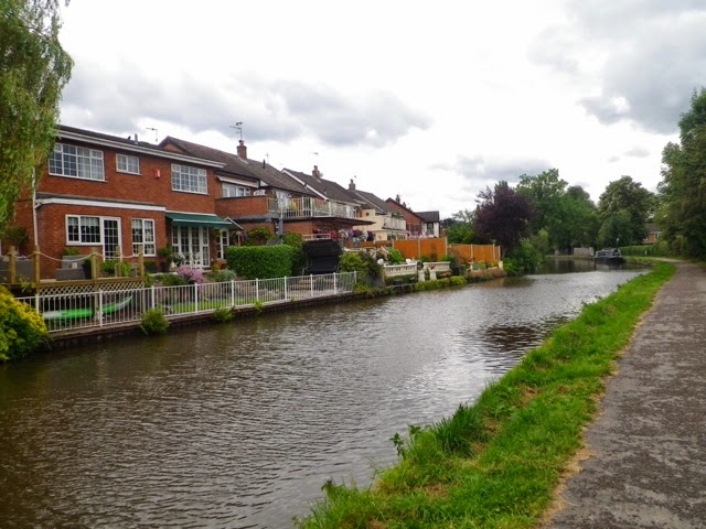


There are some nice homes on the canal.
This was a very low bridge. I had to duck to go under it.
After a number of miles, the towpath crossed to the other side via this bridge.
There are several locks along the canal. The canal boat people have to operate the locks themselves. The boat comes in, and the woman (always the woman--I asked one gal why the woman was always the one to operate the lock. She said she would rather do that than drive the boat!) uses a special tool to let the water in. Once the lock is full, they crank open the door, and push it open. The two gals above were doing it together. The boat in the lock is the "Cool Running" (named after the Jamaican Bobsled Team).
Sometimes, there are several boats waiting. Only one can go at a time.
Here's a bunch waiting.I made it to Stone.
 And, to finish as I started, here's a pair of swans and their babies.
The route continued along the canal for some distance more. I was beginning to wonder if it would go all the way to Stafford, but no. I left the canal, and made my way along the road. It was still a little over 6 miles to Stafford. As I came into Stafford, I picked up the Isabel Trail. That brought me into Stafford proper. Stafford is another good size city. I asked the Garmin about camping. I had come 57 miles. The nearest camping was still 17 miles away, and not necessarily in the right direction (although I think it might have been close enough). The thing is, I didn't really want to do another 17 miles. It was already after 5:00. In addition, Route 5 is not developed from here to Lichfield, so I need to figure out my route.
Sooooo, I am once again in a motel, a Travelodge. The Spencer it is not (but neither is the price). Nigel, the guy at the desk, was a bit slow. First he had to check in everyone who had pre-booked because, well, "I have to fill out all the forms for you." Okaaaayyyy...it was all a little bit nuts, but I'm in a room for the night. I'm in the center of Stafford, curiously, on Lichfield Road. Gee, I wonder what is the way to Lichfield???
1 comment:
Hi Colleen. I am the husband of Frances, who you met in Cheshire on day 56. Having cycled from John O Groats back to Cornwall, and lands End, last year, I am very impressed with your tour account. Frances has suggested I attempt your latest route!!! No doubt on the basis that it would get me out of the house for 80 days. You have, at least, got me thinking. Perhaps across the UK to Harwich and a circumnavigation of the Netherlands. We’ll see. Still need to catch up on the after days of your epic adventure. Dean
Post a Comment